
Location: Novato, CA
Difficulty: Moderate
Features: Hiking trails, bike friendly, bird watching, dogs allowed, wildlife observation
Mount Burdell Open Space Preserve is home to the Burdell Mountain and Hidden Lake, a seasonal pond that is home to a diverse collection of flora and fauna. Moreover, also found within the preserve is a number of interesting trails. One of these is the Upper Mount Burdell Trail. The Upper Mount Burdell Trail forms a loop on the southwest flank of the mountain, through the Hidden Lake, an old stone wall built in the late 1800s by Chinese laborers, and rock quarries. The trail eventually takes hikers to the summit, where stellar views of Mount Diablo and San Francisco can be seen.
About the Mount Burdell Open Space Preserve
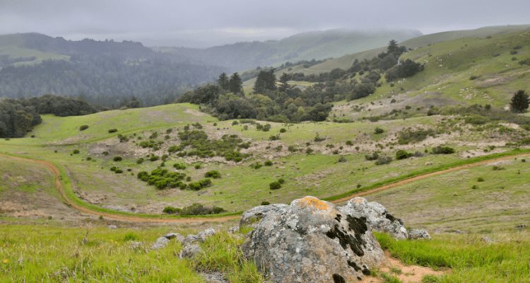
Managed by the Marin County Parks, the Mount Burdell Open Space Preserve houses the 1,500 feet high Mount Burdell and seasonal pond, Hidden Lake. The preserve is home to a wide variety of flora and fauna – with increased population of frogs and salamanders during the wet season. Some portions of the preserve are grazed by domestic cattle. The Mount Burdell Open Space Preserve was purchased in 1977 by the Marin County Open Space District. The preserve boasts the titanic Mount Burdell, standing tall and offers stellar view of the entire Bay Area. En route to the summit, visitors encounter lush grasslands and dense forests filled with the finest and oldest oak and bay tree specimens.
Trails at the Mount Burdell Open Space Preserve
The Mount Burdell Open Space Preserve is home to a number of trails and fire roads. It is also proximate to the Olompali Historic State Park. The preserve is surrounded by fire roads, encircling the entire Mount Burdell area. The San Andreas Fire Road leads to the Deer Camp Fire Road, then to the Cobblestone Fire Road and eventually to the Ridge Fire Road where the Mount Burdell Trail is located. The Michako Trail is a popular trail as it dissects the entire preserve in half. The Old Quarry Trail, meanwhile, is a trail that connects the San Carlos Fire Road with the Ridge Fire Road. All in all, there are plenty of trails surrounding the preserve. A map of the area is highly recommended when hiking within the area.
Top 3 Adventure Hacks
1) Use a comfortable backpack
Long treks on technical terrain can be very straining. Thus, it is important to use a backpack that fits perfectly and curves according to your spine.
2) Bring essential tools
A Swiss knife, multi-purpose tool, flashlight, whistle, and compass are just some of the important tools to bring on a long hike.
3) Don’t get lost. Trails can go for miles
Of course, you don’t want to get lost! A map, GPS, compass are essential devices that can help you located campsites, water, and an emergency exit route in case of emergency.

About the Author
I'm David, Founding Nomad of AdventureHacks, Inc. My mission is to inspire adventure on the ground, in the water and through the air. If I also happen to inspire you to purchase gear, my team and I plant a tree in its native environment for every order.


